
A listing tells you the beds, the baths and the price. It doesn't tell you how often the county floods, how much sun the roof gets or where the nearest charger is. All of that is public. It just sits on seven different government sites.
So I asked an agent, through Delegate's MCP server in Claude Code:
What can I check about 710 W Cesar Chavez St, Austin, TX 78701 before I rent or buy near it? Homes for sale in the ZIP, schools, EV chargers, rooftop solar, earthquakes, disasters, air quality and crime.
That's the Austin Central Library. I used a public building so I'm not publishing anyone's home. Ten services, about five and a half minutes, $0.00847 in all. Only the listings cost money.
| # | Check | Service | What came back | Cost |
|---|---|---|---|---|
| 1 | Homes for sale nearby | Redfin Home Listings by ZIP Code | 10 listings, median $1,200,000 | $0.00847 |
| 2 | EV chargers | EV Charging Stations Near a Location (NREL) | 143 within a mile | $0.00 |
| 3 | Rooftop solar | Solar PV Output Estimate for a Site (NREL PVWatts) | 10,333 kWh a year from 7 kW | $0.00 |
| 4 | Earthquakes | USGS Earthquake Search | 1 of magnitude 2.5+ in 10 years | $0.00 |
| 5 | Disasters | FEMA Disaster Declarations by State and Incident Type | 9 for Travis County since 2016 | $0.00 |
| 6 | Air quality | AirNow Air Quality Index (AQI), Current and Forecast | Good, PM2.5 at 39 | $0.00 |
| 7 | Crime | US Crime Statistics by State or Police Agency (FBI) | 4,232 violent offenses in 2025 | $0.00 |
By hand
- Redfinsearch the ZIP
- AFDC maplook up chargers
- PVWattsmodel the roof
- USGS catalogsearch ten years of quakes
- FEMAfilter Texas down to the county
- AirNowcheck the air today
- FBI explorerfind the right police department
7 sites, 7 search forms
With an agent
Ask about the address
Census geocoder turns it into coordinates
- Redfin listings
- NREL charging stations
- NREL PVWatts
- USGS earthquakes
- FEMA declarations
- AirNow air quality
- FBI crime statistics
Answer with sources
1 question, about 5.5 minutes, under a cent
Before anything else, the agent turned the address into coordinates with the Census Address Geocoder (free): Travis County, census tract 12. Every check below starts from that point.
1. What's for sale around it?
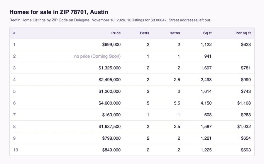
Redfin returned 10 homes for sale in 78701, nine with a price. They ran from $160,000 for a 608 square foot one-bedroom to $4,600,000. The median was $1,200,000. The agent picked Redfin because Zillow quoted $0.057 for 20 results and Redfin $0.00847 for 10.
Two rows needed a second look. One was a "Coming Soon" with no price. The $4.6 million house came back with the city spelled "Ro0nns Austin" and sits in Tarrytown, outside the ZIP.
2. Where can I charge a car?
143 open charging stations within one mile. The nearest is at the library itself, 0.05 miles away, with two Level 2 plugs on the ChargePoint network. The nearest DC fast charger is 0.2 miles away.
3. How much would solar on the roof produce?
A 7 kW array there would make 10,333 kWh a year in NREL's model, from 645 kWh in February to 1,062 in August. That's a typical year, not a forecast.
4. Does the ground shake?
One earthquake of magnitude 2.5 or more within 100 km in ten years: a 2.9 near Flatonia on October 20, 2017. The USGS service searches at most a year at a time, so the agent ran it ten times.
The addressEarthquake, sized by magnitude (2.5 to 4.6)100 km, the radius the agent searched
5. What disasters has the county had?
Nine federal disaster declarations for Travis County since November 2016. The FEMA service filters by state, not county, so the agent read all 1,520 Texas rows and kept the ones for Travis. The most recent was July 2025: severe storms, straight-line winds and flooding.
6. How's the air?
Good at 3 PM local time: PM2.5 at 39, ozone at 37, PM10 at 22. AirNow's forecast moved PM2.5 to Moderate for the next few days, without a number.
7. How much crime is reported?
The Austin Police Department reported 4,232 violent and 31,044 property offenses to the FBI for 2025, for about a million people. That's roughly 423 violent and 3,102 property offenses per 100,000. The same FBI data puts the US at about 330 and 1,552. It covers the whole city, not the block.
What didn't work: schools
Schools were on my list and the agent tried three times. Both school services read NCES's map server, and it didn't answer that day. Neither did it from my own laptop, while the rest of nces.ed.gov loaded fine. So no school names this time. Try again another day, or ask for the district instead.
- services used
- 10
- lookups
- 25
- from question to answers
- about 5.5 min
- in all
- $0.00847
Questions people ask
Can it check my own address?
Yes. Put your address in the prompt instead of the library's. The answers come back in your chat, not on a public page.
Is crime data per block?
No. The FBI numbers are per police department. For a block, look for your city's open data portal.
Why ten earthquake searches?
The USGS service takes a time window of up to a year. The agent split ten years into ten windows on its own.
There are 1,217 services in the catalog today. Open Delegate Agents and ask about the next address on your list. What would you check first?